
Key Insights
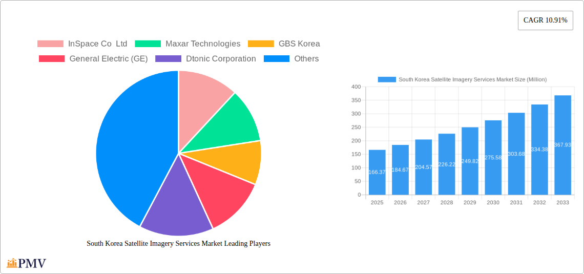
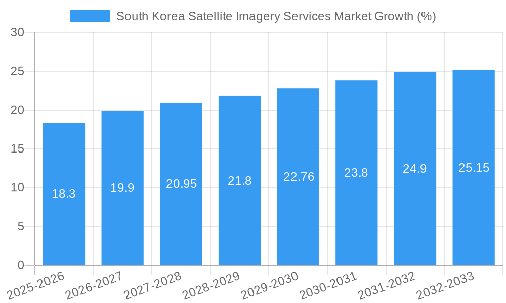
The South Korean satellite imagery services market, valued at $166.37 million in 2025, is projected to experience robust growth, exhibiting a compound annual growth rate (CAGR) of 10.91% from 2025 to 2033. This expansion is fueled by several key drivers. Firstly, increasing government investment in infrastructure projects, particularly in construction and transportation, necessitates high-resolution imagery for planning and monitoring. Secondly, the rising demand for precise geospatial data across various sectors, including agriculture, forestry, and disaster management, is driving adoption. Furthermore, advancements in satellite technology, offering improved image resolution and faster data processing capabilities, contribute significantly to market growth. The market is segmented by application (Geospatial Data Acquisition and Mapping, Natural Resource Management, Surveillance and Security, Conservation and Research, Disaster Management, Intelligence) and end-user (Government, Construction, Transportation and Logistics, Military and Defense, Forestry and Agriculture, Others). Competition is relatively high, with both international players like Maxar Technologies and L3Harris Corporation, and domestic companies like InSpace Co Ltd and Dabeeo Inc vying for market share. The strong focus on national security and technological advancement within South Korea positions this market for continued expansion.
The forecast period (2025-2033) anticipates substantial growth, primarily driven by the ongoing digital transformation across various sectors and increasing reliance on data-driven decision-making. Specific growth opportunities exist in developing advanced analytics capabilities leveraging satellite imagery data. However, data privacy concerns and the high initial investment costs associated with satellite technology and data processing could present challenges. Despite these restraints, the continued governmental support for technological innovation and the expanding applications of satellite imagery suggest a positive outlook for the South Korean satellite imagery services market. The market's future trajectory is closely tied to advancements in AI and machine learning which further enhance the capabilities of imagery analysis and interpretation, opening up new application possibilities.
This comprehensive report provides a detailed analysis of the South Korea satellite imagery services market, covering the period from 2019 to 2033. It offers invaluable insights into market size, segmentation, competitive landscape, growth drivers, and challenges, equipping businesses and investors with the knowledge needed to navigate this dynamic sector. The report utilizes a robust methodology, incorporating both historical data (2019-2024) and future projections (2025-2033), with 2025 serving as the base year and estimated year. The market is segmented by application and end-user, providing a granular understanding of its various components. Key players like InSpace Co Ltd, Maxar Technologies, and Dabeeo Inc. are profiled, highlighting their strategies and contributions to the market's evolution.
South Korea Satellite Imagery Services Market Market Structure & Competitive Dynamics
The South Korea satellite imagery services market exhibits a moderately concentrated structure, with a few dominant players alongside several smaller, specialized firms. Market share distribution varies across segments, with larger players often holding significant positions in high-demand applications like surveillance and security for government clients. The market’s innovation ecosystem is characterized by collaborations between established companies and emerging tech startups. For example, the November 2022 partnership between Dabeeo Inc. and Maxar Technologies showcases this trend. Regulatory frameworks, primarily driven by government agencies overseeing defense and security, play a crucial role in shaping market access and data usage. The availability of substitute technologies, such as drone-based imagery, presents competitive pressure. However, satellite imagery's superior coverage and resolution often maintain its dominance. End-user trends indicate a growing preference for high-resolution, readily accessible data integrated with advanced analytical tools. M&A activity has been moderate but is expected to increase as the market consolidates, with deal values ranging from xx Million to xx Million in recent years.
- Market Concentration: Moderately Concentrated
- Innovation Ecosystem: Strong collaboration between established and emerging players.
- Regulatory Framework: Government oversight influences market access and data usage.
- Product Substitutes: Drone-based imagery, but satellite imagery retains advantages in resolution and coverage.
- End-User Trends: Increasing demand for high-resolution, readily accessible data with advanced analytics.
- M&A Activity: Moderate, expected to increase with deal values ranging from xx Million to xx Million.
South Korea Satellite Imagery Services Market Industry Trends & Insights
The South Korea satellite imagery services market is experiencing robust growth, driven by increasing government investments in infrastructure development and national security, coupled with rising private sector adoption across various industries. Technological advancements, including higher-resolution sensors, improved data processing capabilities, and the integration of AI and machine learning, are fueling innovation and market expansion. Consumer preferences are shifting toward more readily available and user-friendly data platforms. The market's CAGR from 2025 to 2033 is projected at xx%, indicating a significant growth trajectory. Market penetration, particularly in the Geospatial Data Acquisition and Mapping application segment, is expected to reach xx% by 2033, exceeding the current penetration of xx%. Competitive dynamics are characterized by both collaboration and competition, with larger players focusing on strategic partnerships and smaller companies specializing in niche applications.
Dominant Markets & Segments in South Korea Satellite Imagery Services Market
The Government sector is the dominant end-user segment, accounting for xx% of the total market in 2025, driven by its significant investment in national security, infrastructure planning, and disaster management. The Geospatial Data Acquisition and Mapping application segment dominates by application, driven by its widespread use across various industries.
Key Drivers for Government Dominance:
- National Security Initiatives
- Infrastructure Development Projects
- Disaster Management and Response
- Extensive Budget Allocation for Spatial Data
Key Drivers for Geospatial Data Acquisition and Mapping Segment Dominance:
- Urban Planning and Development
- Precision Agriculture and Resource Management
- Construction and Engineering Projects
- Transportation Network Optimization
The strong economic growth and robust infrastructure development programs in South Korea are key factors driving market dominance in both segments.
South Korea Satellite Imagery Services Market Product Innovations
Recent innovations include the integration of AI/ML for automated image analysis, the development of more compact and cost-effective satellite sensors, and the enhancement of cloud-based data processing platforms. These innovations enhance data accessibility, reduce processing times, and improve the accuracy of derived insights, improving the market fit and competitive advantage of providers.
Report Segmentation & Scope
The report segments the South Korea satellite imagery services market by application (Geospatial Data Acquisition and Mapping, Natural Resource Management, Surveillance and Security, Conservation and Research, Disaster Management, Intelligence) and by end-user (Government, Construction, Transportation and Logistics, Military and Defense, Forestry and Agriculture, Others). Each segment’s growth projections, market sizes, and competitive dynamics are analyzed in detail. For instance, the Government segment is expected to exhibit a higher CAGR than other end-user segments due to substantial government spending on defense and national security. Similarly, the Geospatial Data Acquisition and Mapping application segment is projected to experience rapid growth due to its expanding use across various sectors.
Key Drivers of South Korea Satellite Imagery Services Market Growth
Several factors drive the market's growth, including: increasing government investments in infrastructure and defense, rising demand for precise geospatial data across various industries, technological advancements in satellite imagery, the integration of AI/ML for improved data processing, and the growing adoption of cloud-based solutions for data access and analysis.
Challenges in the South Korea Satellite Imagery Services Market Sector
Challenges include stringent data privacy regulations, the high initial investment costs associated with satellite imagery acquisition and processing, dependence on reliable internet infrastructure for data delivery, and potential competition from other geospatial data sources. These factors collectively can impact market expansion and profitability.
Leading Players in the South Korea Satellite Imagery Services Market Market
- InSpace Co Ltd
- Maxar Technologies
- GBS Korea
- General Electric (GE)
- Dtonic Corporation
- ESRI Inc
- L3Harris Corporation Inc
- Soletop
- Bentley Systems Inc
- Dabeeo Inc
Key Developments in South Korea Satellite Imagery Services Market Sector
- November 2022: Dabeeo Inc. partners with Maxar Technologies, expanding its imaging services and access to Maxar's satellite imagery. This partnership significantly boosts Dabeeo's market capabilities.
- August 2022: Yahaha launches an AI mirror world project using Dabeeo's location and geospatial data technology, showcasing the integration of satellite imagery with AI for innovative applications. This development highlights the potential for novel applications within the sector.
Strategic South Korea Satellite Imagery Services Market Market Outlook
The South Korea satellite imagery services market holds immense future potential, driven by continued technological advancements, increasing government spending, and the expanding use of satellite data across various sectors. Strategic opportunities exist in developing innovative AI-powered applications, expanding into niche markets, and establishing strategic partnerships to enhance market reach and service offerings. The market's future is bright, marked by further consolidation and diversification.
South Korea Satellite Imagery Services Market Segmentation
-
1. Application
- 1.1. Geospatial Data Acquisition and Mapping
- 1.2. Natural Resource Management
- 1.3. Surveillance and Security
- 1.4. Conservation and Research
- 1.5. Disaster Management
- 1.6. Intelligence
-
2. End-User
- 2.1. Government
- 2.2. Construction
- 2.3. Transportation and Logistics
- 2.4. Military and Defense
- 2.5. Forestry and Agriculture
- 2.6. Others
South Korea Satellite Imagery Services Market Segmentation By Geography
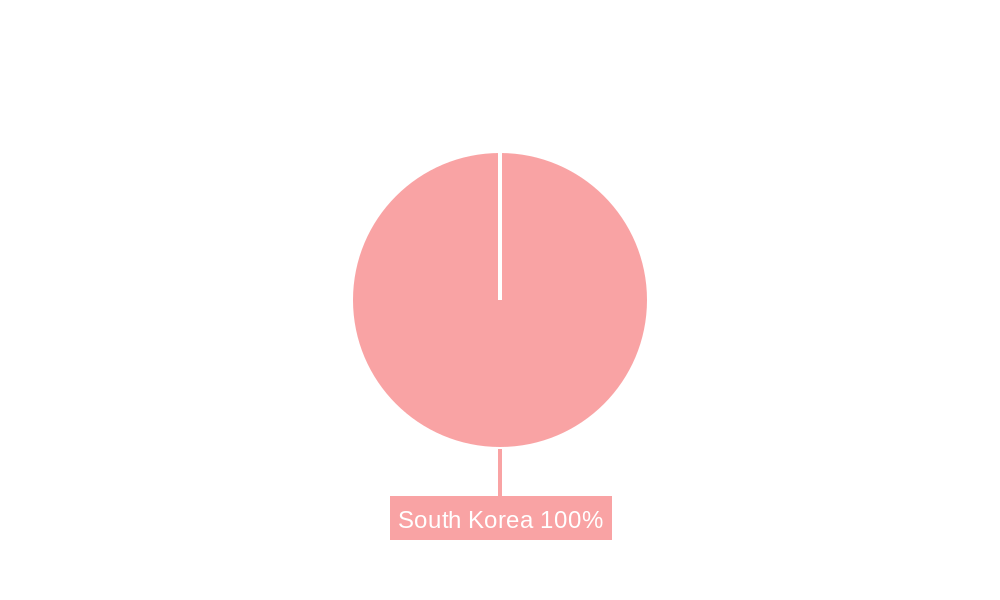
- 1. South Korea
South Korea Satellite Imagery Services Market REPORT HIGHLIGHTS
| Aspects | Details |
|---|---|
| Study Period | 2019-2033 |
| Base Year | 2024 |
| Estimated Year | 2025 |
| Forecast Period | 2025-2033 |
| Historical Period | 2019-2024 |
| Growth Rate | CAGR of 10.91% from 2019-2033 |
| Segmentation |
|
Table of Contents
- 1. Introduction
- 1.1. Research Scope
- 1.2. Market Segmentation
- 1.3. Research Methodology
- 1.4. Definitions and Assumptions
- 2. Executive Summary
- 2.1. Introduction
- 3. Market Dynamics
- 3.1. Introduction
- 3.2. Market Drivers
- 3.2.1. Growing requirement of Security System in South Korea; Rising Smart City Initiatives
- 3.3. Market Restrains
- 3.3.1. Budget Constraints and Technological Limitations
- 3.4. Market Trends
- 3.4.1. Growing Use of Satellite Imagery Services in Military and Defense Sector
- 4. Market Factor Analysis
- 4.1. Porters Five Forces
- 4.2. Supply/Value Chain
- 4.3. PESTEL analysis
- 4.4. Market Entropy
- 4.5. Patent/Trademark Analysis
- 5. South Korea Satellite Imagery Services Market Analysis, Insights and Forecast, 2019-2031
- 5.1. Market Analysis, Insights and Forecast - by Application
- 5.1.1. Geospatial Data Acquisition and Mapping
- 5.1.2. Natural Resource Management
- 5.1.3. Surveillance and Security
- 5.1.4. Conservation and Research
- 5.1.5. Disaster Management
- 5.1.6. Intelligence
- 5.2. Market Analysis, Insights and Forecast - by End-User
- 5.2.1. Government
- 5.2.2. Construction
- 5.2.3. Transportation and Logistics
- 5.2.4. Military and Defense
- 5.2.5. Forestry and Agriculture
- 5.2.6. Others
- 5.3. Market Analysis, Insights and Forecast - by Region
- 5.3.1. South Korea
- 5.1. Market Analysis, Insights and Forecast - by Application
- 6. Competitive Analysis
- 6.1. Market Share Analysis 2024
- 6.2. Company Profiles
- 6.2.1 InSpace Co Ltd
- 6.2.1.1. Overview
- 6.2.1.2. Products
- 6.2.1.3. SWOT Analysis
- 6.2.1.4. Recent Developments
- 6.2.1.5. Financials (Based on Availability)
- 6.2.2 Maxar Technologies
- 6.2.2.1. Overview
- 6.2.2.2. Products
- 6.2.2.3. SWOT Analysis
- 6.2.2.4. Recent Developments
- 6.2.2.5. Financials (Based on Availability)
- 6.2.3 GBS Korea
- 6.2.3.1. Overview
- 6.2.3.2. Products
- 6.2.3.3. SWOT Analysis
- 6.2.3.4. Recent Developments
- 6.2.3.5. Financials (Based on Availability)
- 6.2.4 General Electric (GE)
- 6.2.4.1. Overview
- 6.2.4.2. Products
- 6.2.4.3. SWOT Analysis
- 6.2.4.4. Recent Developments
- 6.2.4.5. Financials (Based on Availability)
- 6.2.5 Dtonic Corporation
- 6.2.5.1. Overview
- 6.2.5.2. Products
- 6.2.5.3. SWOT Analysis
- 6.2.5.4. Recent Developments
- 6.2.5.5. Financials (Based on Availability)
- 6.2.6 ESRI Inc
- 6.2.6.1. Overview
- 6.2.6.2. Products
- 6.2.6.3. SWOT Analysis
- 6.2.6.4. Recent Developments
- 6.2.6.5. Financials (Based on Availability)
- 6.2.7 L3Harris Corporation Inc
- 6.2.7.1. Overview
- 6.2.7.2. Products
- 6.2.7.3. SWOT Analysis
- 6.2.7.4. Recent Developments
- 6.2.7.5. Financials (Based on Availability)
- 6.2.8 Soletop
- 6.2.8.1. Overview
- 6.2.8.2. Products
- 6.2.8.3. SWOT Analysis
- 6.2.8.4. Recent Developments
- 6.2.8.5. Financials (Based on Availability)
- 6.2.9 Bentley Systems Inc
- 6.2.9.1. Overview
- 6.2.9.2. Products
- 6.2.9.3. SWOT Analysis
- 6.2.9.4. Recent Developments
- 6.2.9.5. Financials (Based on Availability)
- 6.2.10 Dabeeo Inc
- 6.2.10.1. Overview
- 6.2.10.2. Products
- 6.2.10.3. SWOT Analysis
- 6.2.10.4. Recent Developments
- 6.2.10.5. Financials (Based on Availability)
- 6.2.1 InSpace Co Ltd
List of Figures
- Figure 1: South Korea Satellite Imagery Services Market Revenue Breakdown (Million, %) by Product 2024 & 2032
- Figure 2: South Korea Satellite Imagery Services Market Share (%) by Company 2024
List of Tables
- Table 1: South Korea Satellite Imagery Services Market Revenue Million Forecast, by Region 2019 & 2032
- Table 2: South Korea Satellite Imagery Services Market Revenue Million Forecast, by Application 2019 & 2032
- Table 3: South Korea Satellite Imagery Services Market Revenue Million Forecast, by End-User 2019 & 2032
- Table 4: South Korea Satellite Imagery Services Market Revenue Million Forecast, by Region 2019 & 2032
- Table 5: South Korea Satellite Imagery Services Market Revenue Million Forecast, by Country 2019 & 2032
- Table 6: South Korea Satellite Imagery Services Market Revenue Million Forecast, by Application 2019 & 2032
- Table 7: South Korea Satellite Imagery Services Market Revenue Million Forecast, by End-User 2019 & 2032
- Table 8: South Korea Satellite Imagery Services Market Revenue Million Forecast, by Country 2019 & 2032
Frequently Asked Questions
1. What is the projected Compound Annual Growth Rate (CAGR) of the South Korea Satellite Imagery Services Market?
The projected CAGR is approximately 10.91%.
2. Which companies are prominent players in the South Korea Satellite Imagery Services Market?
Key companies in the market include InSpace Co Ltd, Maxar Technologies, GBS Korea, General Electric (GE), Dtonic Corporation, ESRI Inc, L3Harris Corporation Inc , Soletop, Bentley Systems Inc, Dabeeo Inc.
3. What are the main segments of the South Korea Satellite Imagery Services Market?
The market segments include Application, End-User.
4. Can you provide details about the market size?
The market size is estimated to be USD 166.37 Million as of 2022.
5. What are some drivers contributing to market growth?
Growing requirement of Security System in South Korea; Rising Smart City Initiatives.
6. What are the notable trends driving market growth?
Growing Use of Satellite Imagery Services in Military and Defense Sector.
7. Are there any restraints impacting market growth?
Budget Constraints and Technological Limitations.
8. Can you provide examples of recent developments in the market?
November 2022 - Dabeeo announced that the company is partnering with Maxar Technology. Through this partnership, Dabeeo is expanding its imaging services. Also, Dabeeo will cooperate with Maxar in various areas, including selling Maxar's satellite images, and will allow Dabeeo to provide more flexible technical collaboration and satellite image data.
9. What pricing options are available for accessing the report?
Pricing options include single-user, multi-user, and enterprise licenses priced at USD 3800, USD 4500, and USD 5800 respectively.
10. Is the market size provided in terms of value or volume?
The market size is provided in terms of value, measured in Million.
11. Are there any specific market keywords associated with the report?
Yes, the market keyword associated with the report is "South Korea Satellite Imagery Services Market," which aids in identifying and referencing the specific market segment covered.
12. How do I determine which pricing option suits my needs best?
The pricing options vary based on user requirements and access needs. Individual users may opt for single-user licenses, while businesses requiring broader access may choose multi-user or enterprise licenses for cost-effective access to the report.
13. Are there any additional resources or data provided in the South Korea Satellite Imagery Services Market report?
While the report offers comprehensive insights, it's advisable to review the specific contents or supplementary materials provided to ascertain if additional resources or data are available.
14. How can I stay updated on further developments or reports in the South Korea Satellite Imagery Services Market?
To stay informed about further developments, trends, and reports in the South Korea Satellite Imagery Services Market, consider subscribing to industry newsletters, following relevant companies and organizations, or regularly checking reputable industry news sources and publications.
Methodology
Step 1 - Identification of Relevant Samples Size from Population Database


Step 2 - Approaches for Defining Global Market Size (Value, Volume* & Price*)

Note*: In applicable scenarios
Step 3 - Data Sources
Primary Research
- Web Analytics
- Survey Reports
- Research Institute
- Latest Research Reports
- Opinion Leaders
Secondary Research
- Annual Reports
- White Paper
- Latest Press Release
- Industry Association
- Paid Database
- Investor Presentations

Step 4 - Data Triangulation
Involves using different sources of information in order to increase the validity of a study
These sources are likely to be stakeholders in a program - participants, other researchers, program staff, other community members, and so on.
Then we put all data in single framework & apply various statistical tools to find out the dynamic on the market.
During the analysis stage, feedback from the stakeholder groups would be compared to determine areas of agreement as well as areas of divergence


