
Key Insights
The Russia Satellite Imagery Services market is experiencing robust growth, driven by increasing government investment in national security and infrastructure development, coupled with rising demand across diverse sectors. The market's Compound Annual Growth Rate (CAGR) of 9.52% from 2019 to 2024 suggests a significant upward trajectory, projected to continue through 2033. Key applications fueling this expansion include geospatial data acquisition and mapping for urban planning and resource management, surveillance and security for border protection and crime prevention, and disaster management for efficient response and recovery efforts. The substantial involvement of government agencies like Roscosmos and military and defense organizations underscores the strategic importance of satellite imagery within the nation's overall development strategy. The market is segmented by end-user (government, construction, transportation & logistics, military & defense, forestry & agriculture, and other end-users) and application (geospatial data acquisition, natural resource management, surveillance & security, conservation & research, disaster management, and intelligence), allowing for a nuanced understanding of market dynamics within specific sectors. Leading companies like Roscosmos, Scanex Group, and others are actively shaping market trends through technological advancements and strategic partnerships. The regional distribution, encompassing Western, Eastern, Southern, and Northern Russia, reflects varying levels of market penetration and growth potential based on regional infrastructure and specific sector needs. Future growth is anticipated to be influenced by technological improvements in satellite imagery resolution and analytics, as well as increasing private sector investment in the sector.
The ongoing expansion of the Russian satellite imagery services market signifies a growing reliance on advanced geospatial technologies for economic growth and national security. This is reflected in the diverse range of applications, from precision agriculture to crucial infrastructure monitoring and defense applications. While specific market size figures for 2025 and beyond are not provided, the consistent CAGR of 9.52% and the inherent market drivers suggest a significant and sustained expansion. The continued investment by both government and private entities in improving satellite technology and analytical capabilities indicates a strong outlook for the Russia Satellite Imagery Services market, promising further growth and innovation in the years ahead.
Russia Satellite Imagery Services Market: A Comprehensive Report (2019-2033)
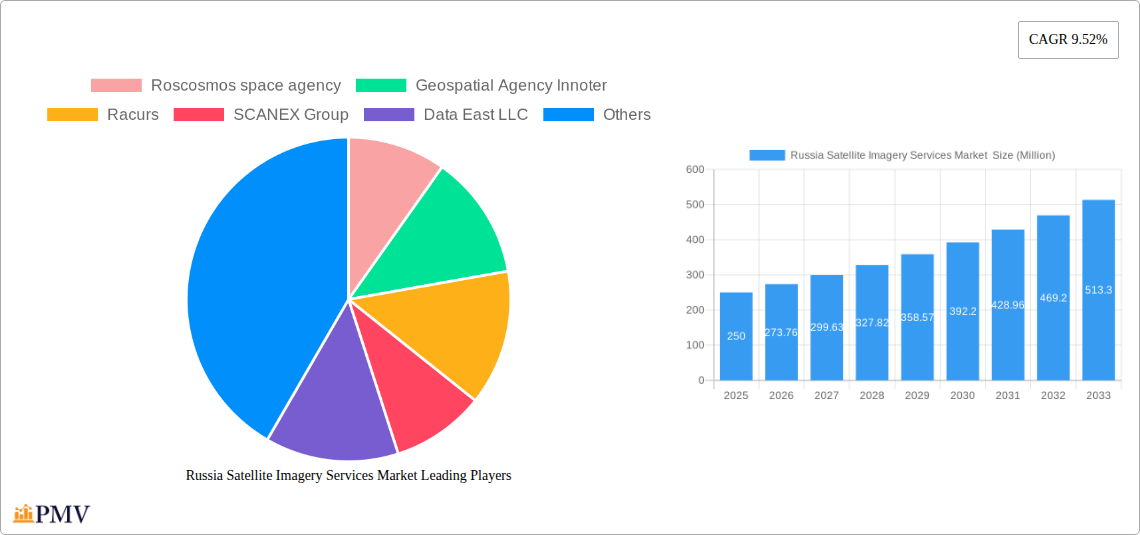
This in-depth report provides a comprehensive analysis of the Russia Satellite Imagery Services Market, offering invaluable insights for businesses, investors, and policymakers. The study covers the period 2019-2033, with 2025 serving as the base and estimated year. The report meticulously examines market size, growth drivers, challenges, competitive dynamics, and future trends, providing actionable intelligence for strategic decision-making. The market is segmented by end-user (Government, Construction, Transportation and Logistics, Military and Defense, Forestry and Agriculture, Other End-Users) and application (Geospatial Data Acquisition and Mapping, Natural Resource Management, Surveillance and Security, Conservation and Research, Disaster Management, Intelligence). Key players like Roscosmos space agency, Geospatial Agency Innoter, Racurs, SCANEX Group, Data East LLC, Geoaler, NextGIS, glavkosmos, and EAST VIEW GEOSPATIAL INC are profiled, providing a holistic view of the market landscape. The total market size in 2025 is estimated at xx Million USD.
Russia Satellite Imagery Services Market Market Structure & Competitive Dynamics
The Russia Satellite Imagery Services Market exhibits a moderately concentrated structure, with a few dominant players holding significant market share. Roscosmos, as the national space agency, plays a pivotal role, though its market share is xx% and is predicted to remain so until 2033. Private companies like SCANEX Group and Racurs contribute significantly to the innovation ecosystem, competing primarily on data quality, resolution, and processing capabilities. The regulatory framework, influenced by government policies, plays a significant role, particularly in sectors like defense and security. Substitutes for satellite imagery include aerial photography and LiDAR, but satellite imagery’s superior coverage and cost-effectiveness offer a significant advantage. End-user trends, particularly the increasing demand for high-resolution imagery from the military and defense sector, drive market growth. M&A activity has been relatively limited, with deal values averaging xx Million USD annually during the historical period, suggesting a stable but not highly consolidated market.
- Market Concentration: Moderately concentrated, with Roscosmos holding xx% market share.
- Innovation Ecosystems: Primarily driven by private companies focusing on data processing and analysis.
- Regulatory Frameworks: Government policies influence access and applications, especially in defense and security.
- M&A Activity: Relatively low, with average deal values at xx Million USD annually (2019-2024).
- End-User Trends: Growing demand for high-resolution imagery from military and defense sectors.
Russia Satellite Imagery Services Market Industry Trends & Insights
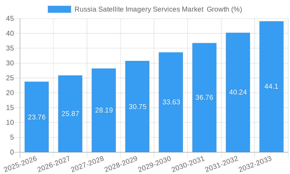
The Russia Satellite Imagery Services Market is projected to experience significant growth, with a Compound Annual Growth Rate (CAGR) of xx% during the forecast period (2025-2033). This growth is fueled by increased government spending on infrastructure projects, rising demand for precise geospatial data across various sectors, and technological advancements in satellite imagery acquisition and processing. The market penetration rate for high-resolution imagery is expected to increase from xx% in 2025 to xx% by 2033. Technological disruptions, including the development of AI-powered image analysis tools and improved satellite sensor technologies, are further accelerating market expansion. Consumer preferences are shifting towards cost-effective, high-quality, and readily accessible satellite imagery solutions. Competitive dynamics are characterized by a mix of established players and emerging firms, fostering innovation and driving price competition.
Dominant Markets & Segments in Russia Satellite Imagery Services Market
The Military and Defense sector is the dominant end-user segment, driven by the ongoing geopolitical situation and the need for enhanced surveillance capabilities. The Government sector also plays a significant role, utilizing satellite imagery for infrastructure development and resource management.
Dominant Segment Drivers:
- Military and Defense: Increased surveillance needs due to ongoing conflicts and border security concerns.
- Government: Investment in infrastructure projects and resource management initiatives.
Dominance Analysis:
The Military and Defence sector’s dominance stems from the increased need for real-time intelligence gathering and target surveillance, particularly due to recent geopolitical events. Government agencies also rely heavily on satellite imagery for infrastructure planning, disaster response, and environmental monitoring. The substantial investment in these sectors translates to high demand for satellite imagery services, significantly influencing market growth. The high-resolution imagery needed for such applications contributes to a higher average revenue per user, contributing to the overall market value.
Russia Satellite Imagery Services Market Product Innovations
Recent advancements in satellite technology have led to the development of high-resolution imagery with improved spectral capabilities, enabling more precise and detailed analysis. AI-powered image processing techniques are enhancing the speed and accuracy of data extraction and interpretation. These innovations cater to the growing demand for precise, actionable intelligence across various sectors. Market fit is demonstrated by the increasing adoption of these technologies by key end-users, such as government agencies and defense contractors. The integration of cloud computing and big data technologies enables cost-effective storage and processing of vast amounts of satellite imagery data, boosting market efficiency and accessibility.
Report Segmentation & Scope
The report segments the market by end-user: Government, Construction, Transportation and Logistics, Military and Defense, Forestry and Agriculture, and Other End-Users. Each segment showcases distinct growth trajectories and competitive landscapes. The Military and Defense segment is expected to dominate, while the Construction and Transportation sectors also show promising growth.
By application, the market is segmented into: Geospatial Data Acquisition and Mapping, Natural Resource Management, Surveillance and Security, Conservation and Research, Disaster Management, and Intelligence. The Surveillance and Security application exhibits the highest growth potential, driven by increased demand for real-time intelligence and enhanced security measures. Each segment displays unique dynamics, impacting the overall market composition and growth projection. Growth projections, market sizes, and competitive dynamics are detailed within the full report.
Key Drivers of Russia Satellite Imagery Services Market Growth
Several factors fuel the growth of the Russia Satellite Imagery Services Market. Government initiatives promoting infrastructure development and technological advancements in satellite technology contribute significantly. Increased investment in the defense and security sectors further drives demand for high-resolution imagery. Moreover, the rising adoption of GIS technologies and growing awareness of the applications of satellite imagery across various sectors, including agriculture and resource management, significantly contribute to the market's growth.
Challenges in the Russia Satellite Imagery Services Market Sector
Challenges include the reliance on import of certain technologies, potentially impacting the cost and availability of high-end systems. The sanctions imposed on Russia and the resulting supply chain disruptions might affect the procurement of components and the overall cost of services. Competitive pressures, particularly from international players with advanced capabilities, pose a considerable challenge. Furthermore, the complexities of data handling, processing, and analysis require specialized skills, creating a demand for skilled professionals within the industry.
Leading Players in the Russia Satellite Imagery Services Market Market
- Roscosmos space agency
- Geospatial Agency Innoter
- Racurs
- SCANEX Group
- Data East LLC
- Geoaler
- NextGIS
- glavkosmos
- EAST VIEW GEOSPATIAL INC
Key Developments in Russia Satellite Imagery Services Market Sector
- August 2022: Launch of an earth observatory satellite to provide satellite services in Iran, including satellite imagery, and increased surveillance of military targets in Ukraine. This event significantly impacted the Military and Defence segment.
- April 2023: Continued participation in the International Space Station (ISS) until at least 2028. This long-term commitment supports the growth of the country's satellite ecosystem and boosts the demand for satellite imagery services.
Strategic Russia Satellite Imagery Services Market Market Outlook
The Russia Satellite Imagery Services Market presents significant opportunities for growth. Continued investment in space technology, coupled with increasing demand across various sectors, promises a substantial expansion in the coming years. Strategic partnerships between private companies and government agencies can further accelerate market growth and innovation. The development of advanced analytics and AI-powered image processing capabilities will enhance market efficiency and unlock new applications for satellite imagery. The market outlook is positive, indicating strong potential for sustained expansion and technological advancements.
Russia Satellite Imagery Services Market Segmentation
-
1. Application
- 1.1. Geospatial Data Acquisition and Mapping
- 1.2. Natural Resource Management
- 1.3. Surveillance and Security
- 1.4. Conservation and Research
- 1.5. Disaster Management
- 1.6. Intelligence
-
2. End-User
- 2.1. Government
- 2.2. Construction
- 2.3. Transportation and Logistics
- 2.4. Military and Defense
- 2.5. Forestry and Agriculture
- 2.6. Other End-Users
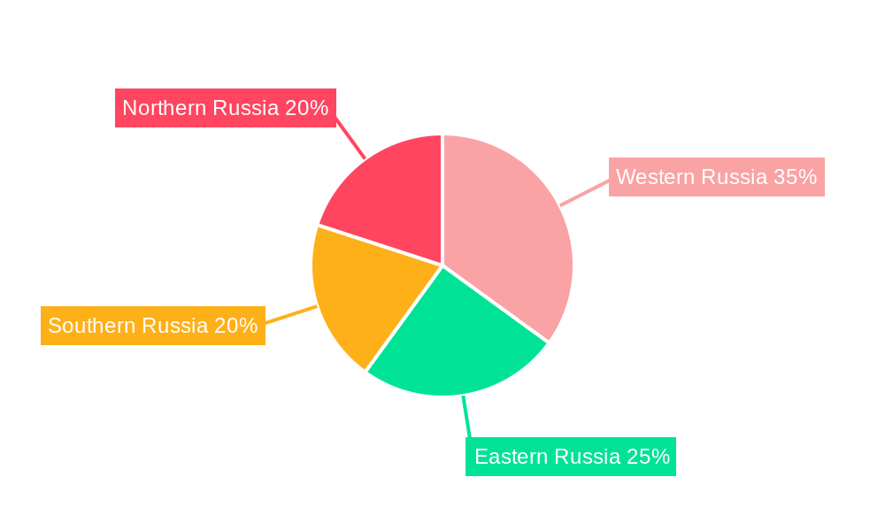
Russia Satellite Imagery Services Market Segmentation By Geography
- 1. Russia
Russia Satellite Imagery Services Market REPORT HIGHLIGHTS
| Aspects | Details |
|---|---|
| Study Period | 2019-2033 |
| Base Year | 2024 |
| Estimated Year | 2025 |
| Forecast Period | 2025-2033 |
| Historical Period | 2019-2024 |
| Growth Rate | CAGR of 9.52% from 2019-2033 |
| Segmentation |
|
Table of Contents
- 1. Introduction
- 1.1. Research Scope
- 1.2. Market Segmentation
- 1.3. Research Methodology
- 1.4. Definitions and Assumptions
- 2. Executive Summary
- 2.1. Introduction
- 3. Market Dynamics
- 3.1. Introduction
- 3.2. Market Drivers
- 3.2.1. The country's Investments in Space Technology and Defence; Adoption of Big Data and Imagery Analytics
- 3.3. Market Restrains
- 3.3.1. High Cost of Satellite Imaging Data Acquisition and Processing; High-resolution Images Offered by Other Imaging Technologies
- 3.4. Market Trends
- 3.4.1. The country's Investments in Space Technology and Defence Drives the Market Growth
- 4. Market Factor Analysis
- 4.1. Porters Five Forces
- 4.2. Supply/Value Chain
- 4.3. PESTEL analysis
- 4.4. Market Entropy
- 4.5. Patent/Trademark Analysis
- 5. Russia Satellite Imagery Services Market Analysis, Insights and Forecast, 2019-2031
- 5.1. Market Analysis, Insights and Forecast - by Application
- 5.1.1. Geospatial Data Acquisition and Mapping
- 5.1.2. Natural Resource Management
- 5.1.3. Surveillance and Security
- 5.1.4. Conservation and Research
- 5.1.5. Disaster Management
- 5.1.6. Intelligence
- 5.2. Market Analysis, Insights and Forecast - by End-User
- 5.2.1. Government
- 5.2.2. Construction
- 5.2.3. Transportation and Logistics
- 5.2.4. Military and Defense
- 5.2.5. Forestry and Agriculture
- 5.2.6. Other End-Users
- 5.3. Market Analysis, Insights and Forecast - by Region
- 5.3.1. Russia
- 5.1. Market Analysis, Insights and Forecast - by Application
- 6. Western Russia Russia Satellite Imagery Services Market Analysis, Insights and Forecast, 2019-2031
- 7. Eastern Russia Russia Satellite Imagery Services Market Analysis, Insights and Forecast, 2019-2031
- 8. Southern Russia Russia Satellite Imagery Services Market Analysis, Insights and Forecast, 2019-2031
- 9. Northern Russia Russia Satellite Imagery Services Market Analysis, Insights and Forecast, 2019-2031
- 10. Competitive Analysis
- 10.1. Market Share Analysis 2024
- 10.2. Company Profiles
- 10.2.1 Roscosmos space agency
- 10.2.1.1. Overview
- 10.2.1.2. Products
- 10.2.1.3. SWOT Analysis
- 10.2.1.4. Recent Developments
- 10.2.1.5. Financials (Based on Availability)
- 10.2.2 Geospatial Agency Innoter
- 10.2.2.1. Overview
- 10.2.2.2. Products
- 10.2.2.3. SWOT Analysis
- 10.2.2.4. Recent Developments
- 10.2.2.5. Financials (Based on Availability)
- 10.2.3 Racurs
- 10.2.3.1. Overview
- 10.2.3.2. Products
- 10.2.3.3. SWOT Analysis
- 10.2.3.4. Recent Developments
- 10.2.3.5. Financials (Based on Availability)
- 10.2.4 SCANEX Group
- 10.2.4.1. Overview
- 10.2.4.2. Products
- 10.2.4.3. SWOT Analysis
- 10.2.4.4. Recent Developments
- 10.2.4.5. Financials (Based on Availability)
- 10.2.5 Data East LLC
- 10.2.5.1. Overview
- 10.2.5.2. Products
- 10.2.5.3. SWOT Analysis
- 10.2.5.4. Recent Developments
- 10.2.5.5. Financials (Based on Availability)
- 10.2.6 Geoaler
- 10.2.6.1. Overview
- 10.2.6.2. Products
- 10.2.6.3. SWOT Analysis
- 10.2.6.4. Recent Developments
- 10.2.6.5. Financials (Based on Availability)
- 10.2.7 NextGIS
- 10.2.7.1. Overview
- 10.2.7.2. Products
- 10.2.7.3. SWOT Analysis
- 10.2.7.4. Recent Developments
- 10.2.7.5. Financials (Based on Availability)
- 10.2.8 glavkosmos
- 10.2.8.1. Overview
- 10.2.8.2. Products
- 10.2.8.3. SWOT Analysis
- 10.2.8.4. Recent Developments
- 10.2.8.5. Financials (Based on Availability)
- 10.2.9 EAST VIEW GEOSPATIAL INC
- 10.2.9.1. Overview
- 10.2.9.2. Products
- 10.2.9.3. SWOT Analysis
- 10.2.9.4. Recent Developments
- 10.2.9.5. Financials (Based on Availability)
- 10.2.1 Roscosmos space agency
List of Figures
- Figure 1: Russia Satellite Imagery Services Market Revenue Breakdown (Million, %) by Product 2024 & 2032
- Figure 2: Russia Satellite Imagery Services Market Share (%) by Company 2024
List of Tables
- Table 1: Russia Satellite Imagery Services Market Revenue Million Forecast, by Region 2019 & 2032
- Table 2: Russia Satellite Imagery Services Market Revenue Million Forecast, by Application 2019 & 2032
- Table 3: Russia Satellite Imagery Services Market Revenue Million Forecast, by End-User 2019 & 2032
- Table 4: Russia Satellite Imagery Services Market Revenue Million Forecast, by Region 2019 & 2032
- Table 5: Russia Satellite Imagery Services Market Revenue Million Forecast, by Country 2019 & 2032
- Table 6: Western Russia Russia Satellite Imagery Services Market Revenue (Million) Forecast, by Application 2019 & 2032
- Table 7: Eastern Russia Russia Satellite Imagery Services Market Revenue (Million) Forecast, by Application 2019 & 2032
- Table 8: Southern Russia Russia Satellite Imagery Services Market Revenue (Million) Forecast, by Application 2019 & 2032
- Table 9: Northern Russia Russia Satellite Imagery Services Market Revenue (Million) Forecast, by Application 2019 & 2032
- Table 10: Russia Satellite Imagery Services Market Revenue Million Forecast, by Application 2019 & 2032
- Table 11: Russia Satellite Imagery Services Market Revenue Million Forecast, by End-User 2019 & 2032
- Table 12: Russia Satellite Imagery Services Market Revenue Million Forecast, by Country 2019 & 2032
Frequently Asked Questions
1. What is the projected Compound Annual Growth Rate (CAGR) of the Russia Satellite Imagery Services Market ?
The projected CAGR is approximately 9.52%.
2. Which companies are prominent players in the Russia Satellite Imagery Services Market ?
Key companies in the market include Roscosmos space agency, Geospatial Agency Innoter, Racurs, SCANEX Group, Data East LLC, Geoaler, NextGIS, glavkosmos, EAST VIEW GEOSPATIAL INC.
3. What are the main segments of the Russia Satellite Imagery Services Market ?
The market segments include Application, End-User.
4. Can you provide details about the market size?
The market size is estimated to be USD XX Million as of 2022.
5. What are some drivers contributing to market growth?
The country's Investments in Space Technology and Defence; Adoption of Big Data and Imagery Analytics.
6. What are the notable trends driving market growth?
The country's Investments in Space Technology and Defence Drives the Market Growth.
7. Are there any restraints impacting market growth?
High Cost of Satellite Imaging Data Acquisition and Processing; High-resolution Images Offered by Other Imaging Technologies.
8. Can you provide examples of recent developments in the market?
April 2023: The Russian government has agreed to continue participation in the International Space Station (ISS) until at least 2028 with NASA, the Canadian Space Agency, the Japan Aerospace Agency, and the European Space Agency, which has extended their agreement with the ISS, and would support the growth of the country's satellite ecosystem and would support the need for satellite imagery services in Russia.
9. What pricing options are available for accessing the report?
Pricing options include single-user, multi-user, and enterprise licenses priced at USD 3800, USD 4500, and USD 5800 respectively.
10. Is the market size provided in terms of value or volume?
The market size is provided in terms of value, measured in Million.
11. Are there any specific market keywords associated with the report?
Yes, the market keyword associated with the report is "Russia Satellite Imagery Services Market ," which aids in identifying and referencing the specific market segment covered.
12. How do I determine which pricing option suits my needs best?
The pricing options vary based on user requirements and access needs. Individual users may opt for single-user licenses, while businesses requiring broader access may choose multi-user or enterprise licenses for cost-effective access to the report.
13. Are there any additional resources or data provided in the Russia Satellite Imagery Services Market report?
While the report offers comprehensive insights, it's advisable to review the specific contents or supplementary materials provided to ascertain if additional resources or data are available.
14. How can I stay updated on further developments or reports in the Russia Satellite Imagery Services Market ?
To stay informed about further developments, trends, and reports in the Russia Satellite Imagery Services Market , consider subscribing to industry newsletters, following relevant companies and organizations, or regularly checking reputable industry news sources and publications.
Methodology
Step 1 - Identification of Relevant Samples Size from Population Database


Step 2 - Approaches for Defining Global Market Size (Value, Volume* & Price*)

Note*: In applicable scenarios
Step 3 - Data Sources
Primary Research
- Web Analytics
- Survey Reports
- Research Institute
- Latest Research Reports
- Opinion Leaders
Secondary Research
- Annual Reports
- White Paper
- Latest Press Release
- Industry Association
- Paid Database
- Investor Presentations

Step 4 - Data Triangulation
Involves using different sources of information in order to increase the validity of a study
These sources are likely to be stakeholders in a program - participants, other researchers, program staff, other community members, and so on.
Then we put all data in single framework & apply various statistical tools to find out the dynamic on the market.
During the analysis stage, feedback from the stakeholder groups would be compared to determine areas of agreement as well as areas of divergence


